


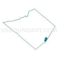
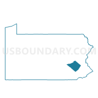
DOUGLASS TWP DIST 01, Berks County, Pennsylvania
About
Outline

Summary
| Unique Area Identifier | 657402 |
| Name | DOUGLASS TWP DIST 01 |
| County | Berks County |
| State | Pennsylvania |
| Area (square miles) | 6.71 |
| Land Area (square miles) | 6.62 |
| Water Area (square miles) | 0.09 |
| % of Land Area | 98.59 |
| % of Water Area | 1.41 |
| Latitude of the Internal Point | 40.27128180 |
| Longtitude of the Internal Point | -75.69354610 |
Maps

Graphs
Select a template below for downloading or customizing gragh for DOUGLASS TWP DIST 01, Berks County, Pennsylvania


Neighbors
Neighoring Voting District (by Name) Neighboring Voting District on the Map
- AMITY TWP DIST 02, Berks County, PA
- AMITY TWP DIST 05, Berks County, PA
- DOUGLASS TWP DIST 02, Berks County, PA
- NORTH COVENTRY TWP VTD WEST, Chester County, PA
- UNION TWP DIST 01, Berks County, PA
- UPPER POTTSGROVE TWP Voting District, Montgomery County, PA
- WEST POTTSGROVE TWP Voting District, Montgomery County, PA
Top 10 Neighboring County Subdivision (by Population) Neighboring County Subdivision on the Map
- Amity township, Berks County, PA (12,583)
- North Coventry township, Chester County, PA (7,866)
- Upper Pottsgrove township, Montgomery County, PA (5,315)
- West Pottsgrove township, Montgomery County, PA (3,874)
- Union township, Berks County, PA (3,503)
- Douglass township, Berks County, PA (3,306)
Top 10 Neighboring Place (by Population) Neighboring Place on the Map
Top 10 Neighboring Unified School District (by Population) Neighboring Unified School District on the Map
- Boyertown Area School District, PA (46,133)
- Owen J. Roberts School District, PA (32,804)
- Daniel Boone Area School District, PA (21,249)
- Pottsgrove School District, PA (21,248)
Top 10 Neighboring State Legislative District Lower Chamber (by Population) Neighboring State Legislative District Lower Chamber on the Map
- State House District 26, PA (74,084)
- State House District 146, PA (70,472)
- State House District 130, PA (70,334)
Top 10 Neighboring State Legislative District Upper Chamber (by Population) Neighboring State Legislative District Upper Chamber on the Map
Top 10 Neighboring 111th Congressional District (by Population) Neighboring 111th Congressional District on the Map
Top 10 Neighboring Census Tract (by Population) Neighboring Census Tract on the Map
- Census Tract 119.04, Berks County, PA (7,553)
- Census Tract 130, Berks County, PA (6,501)
- Census Tract 2091, Montgomery County, PA (5,315)
- Census Tract 3014.02, Chester County, PA (5,056)
- Census Tract 119.03, Berks County, PA (5,030)
- Census Tract 119.02, Berks County, PA (3,503)
- Census Tract 2092.01, Montgomery County, PA (1,587)